
Theta Informatics LLC
Theta provides software called OpenAthena™ that allows common drones to spot precise locations instantly.
Install:
About OpenAthena™:
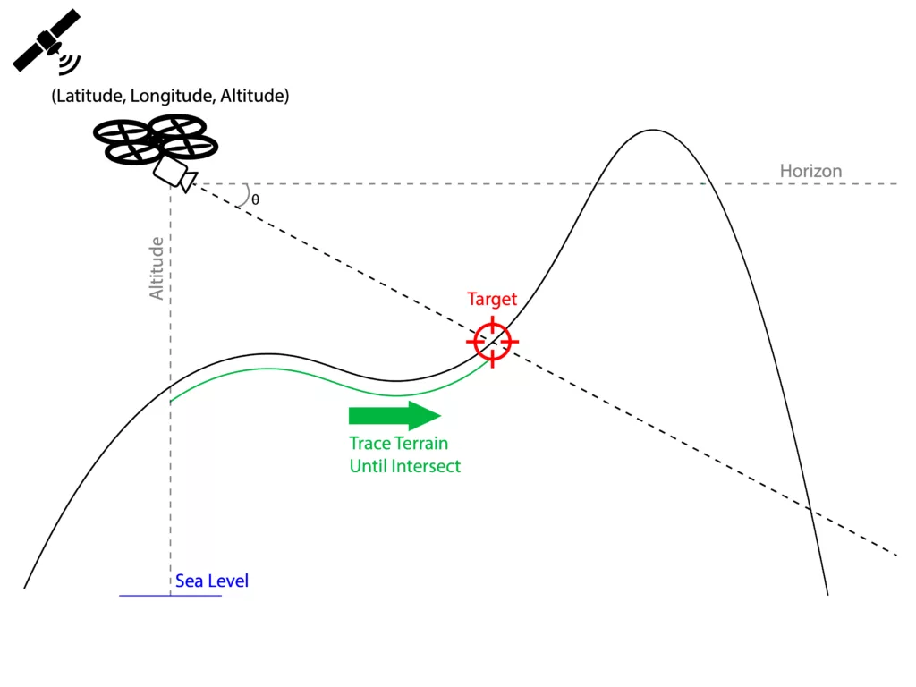
Theta’s OpenAthena software features a novel terrain-raycast technique for location analysis. You can use it to instantly obtain the exact location of any pixel within any image from your regular off-the-shelf drone.
OpenAthena turns your complex mapping task into a simple, quick action. It uses your drone’s camera view and its location to pinpoint exactly where something is on the ground from just one pixel in one photo.
Unlike other methods that require many photos and lots of time, OpenAthena does it instantly, saving you time and effort:
OpenAthena is calibrated for the cameras on over 50 models of DJI, Skydio, Parrot, Teal, and Autel Robotics drones, ensuring good accuracy with most common models.
The OpenAthena software is available in several versions including an iOS+Android mobile app, a Desktop application, and a software library designed for drone manufacturers called OpenAthena Core.
OpenAthena features a novel terrain-raycast technique which combines drone camera position and orientation metadata with digital terrain models to instantly locate whatever your drone’s camera can see. It is significantly faster than conventional techniques as it calculates instantly, from just a single pixel in a single drone image frame:
All version of OpenAthena are built 100% from our own source code (no insecure DJI, Autel SDK, or other dependencies) and is digitally-signed to ensure integrity and security. OpenAthena is a platform you can trust.
OpenAthena is not just software; it’s a revolution across fields like agriculture, search and rescue, environmental protection, and beyond, making critical tasks easier, faster, and more accurate. Whether it’s boosting farm yields, protecting forests from wildfires, or saving lives in emergency situations, our technology is designed to meet diverse needs with unmatched accuracy. What innovative solutions can OpenAthena bring to your work?
More:
Don’t hesitate to contact us to explore how this technology can solve your challenges and propel your projects forward.